
Rivers
How to Read a USGS Stream Gauge for Fishing
USGS streamgages report water level and often compute discharge. Learn what gage height, flow, and temperature mean for trip planning — and what they never tell you by themselves.
StrikeTracks Editorial TeamUpdated 3 min read
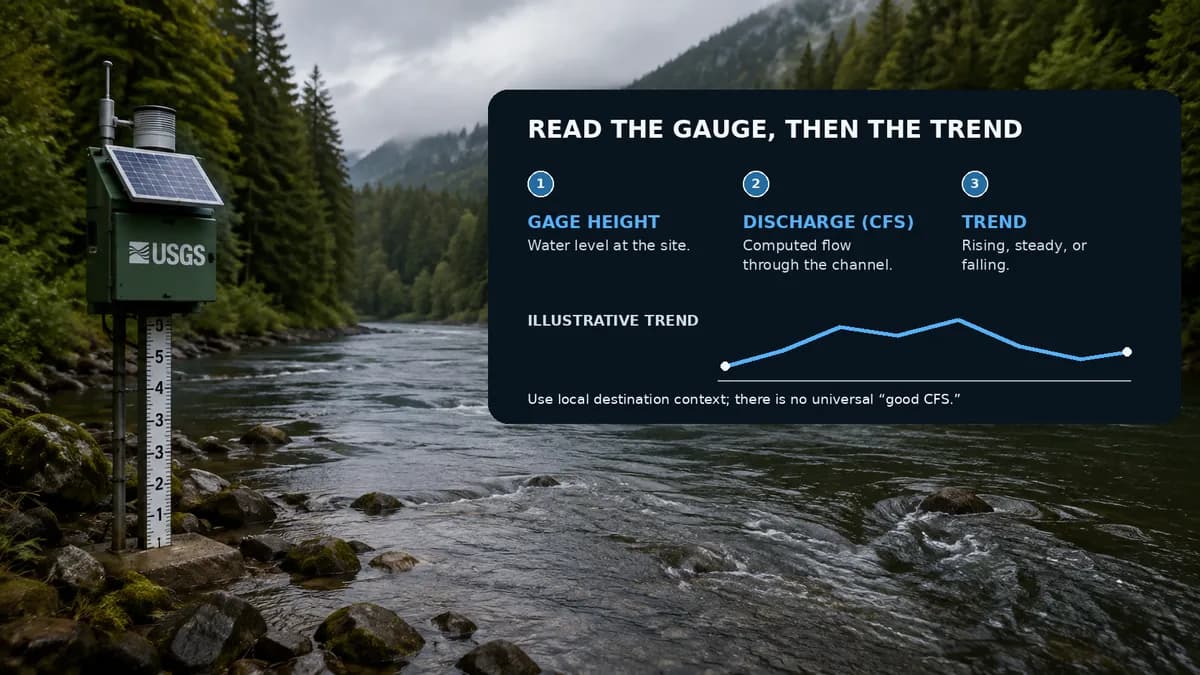
A USGS streamgage is a structure beside a stream or river with instruments that measure and record water level, called gage height or stage. Most gages in the National Streamflow Network also support continuous streamflow information. Many anglers bookmark a gage page. Fewer people know what the numbers are actually measuring.
Gage height is not the depth at your boots
Gage height is the height of the water surface above a local gage datum — a fixed reference chosen for that site. USGS explains that the datum is typically set below the streambed so the reference stays stable as the channel scours or fills. That means a reading of 3.2 feet is not “3.2 feet deep where I wade.” It is 3.2 feet above that site’s datum. Comparing raw gage height between two rivers is usually meaningless.
USGS also notes that some gages record only water level, with no computed discharge. Lakes and some stage-only sites are in that category. If you only see height, do not invent a flow.
Discharge is computed, not scooped out of the river continuously
Direct, continuous measurement of the volume of water passing a point is impractical. USGS hydrographers develop a stage-discharge rating by making on-site discharge measurements and relating them to gage height. The rating is site-specific. Channel change can require rating updates. Real-time values are commonly transmitted on a short interval — often about 15 minutes at many sites, and more frequently during floods at some — and they may be marked provisional until they are reviewed.
Common parameters anglers actually use
USGS identifies measurements with five-digit parameter codes. Discharge in cubic feet per second is commonly 00060. Gage height in feet is commonly 00065. Water temperature in degrees Celsius is commonly 00010. Not every site reports every parameter. A gage can be excellent for flow and silent on temperature, or the reverse.
How to read a gage like a trip-planning tool
- Confirm you have the right site. Rivers have many gages. Upstream versus downstream, tributary versus mainstem, and “near” versus “at” the reach you will fish are different relationships.
- Look at the recent trace, not only the latest tick. Rising after rain, dropping after a pulse, and holding steady are different fishing problems.
- Treat temperature, if present, as its own series. It does not convert into a safe-wading flow.
- If the site is ice-affected, estimated, or missing, believe the qualifier. A stale or ice-affected stage is not a license to guess.
One actual gage StrikeTracks uses
Swift River at West Ware is tied to USGS 01175500. Open the USGS monitoring-location page and the StrikeTracks destination together. Discharge (parameter 00060) is the computed flow in cubic feet per second. Gage height (00065) is stage above the local datum, not the water over your boots. Water temperature (00010) appears only if the site actually reports it; missing temperature stays missing.
The latest tick answers “what did the instrument just send?” The hydrograph answers “is this a spike, a drop, or a hold?” StrikeTracks Historical Flow is the destination-scoped version of that second question. Neither view licenses a universal good CFS. The Swift Good band is 30–80 cfs on a small tailwater; the same numeral on Susquehanna River at Harrisburg would be a different planet. How to Read a StrikeTracks River Hydrograph for an Actual Trip stays on this reach. Research & Methodology states the publisher rule: no invented live readings in Insights.
How StrikeTracks uses gages
StrikeTracks river destinations that are Monitoring-backed have an accepted relationship to qualifying sources. The product is deliberately conservative about treating a nearby gage as if it were the reach you will stand in. That is an evidence decision, not a missing map pin.
When you open a river on StrikeTracks, you are not looking at a raw USGS HTML dump. You are looking at observations after StrikeTracks’ destination contract: what is current, what is missing, and what the evaluator is allowed to do with flow and temperature. For the hydrology itself, How River Flow Affects Fishing Conditions is the companion article. For the difference between a live gage relationship and Estimated Conditions, start with Monitoring-Backed vs. Estimated Fishing Conditions.
A gage cannot tell you whether access is legal, whether a dam is generating, or whether you should step in. It can tell you what the instrument measured at a documented place. Used that way, it is one of the best public tools an angler has.
Sources and methodology
These are the primary sources this article actually relies on. Linked agencies do not endorse StrikeTracks conclusions.
- USGS streamgaging basics — USGS explains that streamgages measure stage and that discharge is computed with a site-specific stage-discharge rating, not scooped continuously from the river.
- USGS: why gage height is not the stream bottom — Gage height is the water-surface elevation above a local datum. It is not wading depth at your boots.
- USGS 01175500 — Swift River at West Ware, MA — The monitoring location assigned to StrikeTracks destination Swift River at West Ware. Use the station page for current and historical stage and discharge; this article does not invent a live reading.
- StrikeTracks Research & Methodology — USGS 01175500 is the StrikeTracks-assigned gage for Swift River at West Ware. Stage versus discharge and hydrograph versus latest tick follow USGS public explainers plus the destination contract.
Related Fishing Insights
- How River Flow Affects Fishing Conditions
Flow changes how a river fishes, how it looks, and how safely you can enter it. This article explains discharge in angler terms and how StrikeTracks uses destination-specific flow context.
- How to Read a StrikeTracks River Hydrograph for an Actual Trip
A hydrograph is a history, not a single tick. Using Swift River at West Ware, this article separates latest discharge from trend, and fishing suitability from wading safety.
- Why Two Rivers With the Same CFS Can Get Different StrikeTracks Guidance
Cubic feet per second is a volume through a channel, not a universal fishing grade. Two real StrikeTracks rivers show why copying a “good CFS” from one water to another is a planning error.